

Nov 2021
By Jas Wong
Despite consistently being regarded as one of the best airports in the world, Changi Airport has never rested on its laurels.
Even during the Covid-19 pandemic lull period, the engineers at Changi Airport Group (CAG) have been busy experimenting with new technologies to transform conventional ways of airfield maintenance, pushing the boundaries of manpower productivity, environmental sustainability, process and cost efficiencies towards greater heights.
Realising man-less grass-cutting
Changi Airport’s turfed areas in the airfield spanning Runways 1, 2 and 3 is the size of around 1,000 standard football fields
In the airfield, other than paved runways, taxiways and aircraft parking aprons, the grounds around aircraft movement areas have to be obstacle-free for safety purposes. These grounds are planted with selective species of turf to avoid soil erosion, that could stir up loose particles under weather and jet blast conditions which could harm aircraft engines in operation. The grassy grounds also help to provide a cushion in the rare event of an aircraft excursion and serve as a channel for absorbing surface water run-off during a storm as well as attenuate noise of aircraft bouncing off the terrain.
One concern regarding these vast, grassy grounds is that they can potentially attract wildlife such as birds or small animals which can pose danger to aircraft. From experience, the grass in the airfield needs to be kept at an optimal height because shorter grass may draw birds to spot prey from the air while longer grass could become a sanctuary encouraging wildlife to hide.
Conventionally, the only way to maintain the grass height is for contractors to cut them regularly, coordinating with air traffic control in real time in case big grass-cutting machines driven by workers need to go near aircraft movement areas. After the cutting is done, the loose grass blades have to be collected in bags manually or through a man-driven mechanical collector, to prevent them from being blown by the wind around the airfield into aircraft engines.
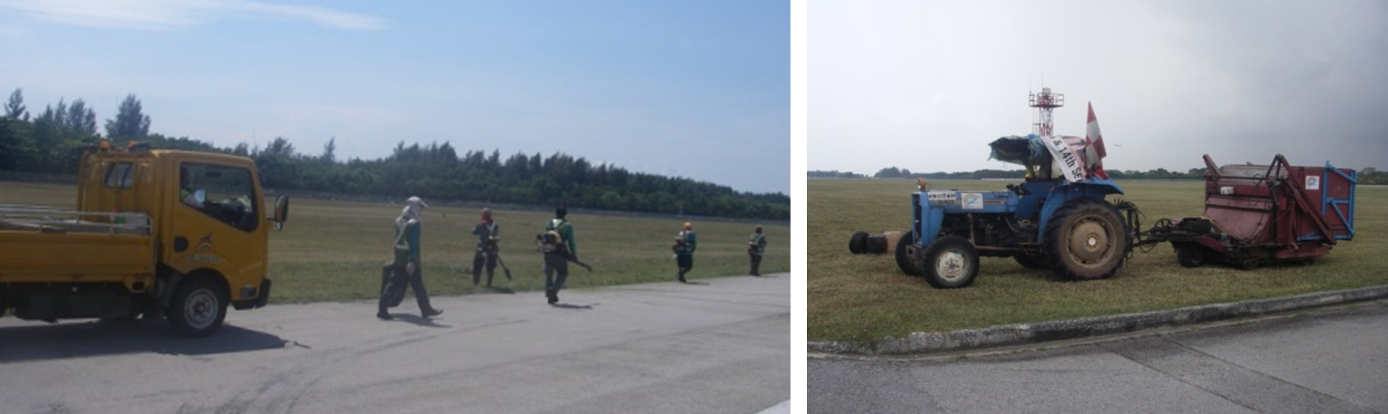
Conventional manpower and machine-intensive grass cutting processes around the airfield
To move away from this manual process, CAG has embarked on trials to deploy smart robotic solutions to automate the grass-cutting process in the airfield, starting first with turfed areas outside the safety zone of aircraft movement areas. The engineering team started with one robot in 2018, to three in 2019, then seven in 2020. Encouraged by the very promising results, more robots have been added to the fleet and the coverage area expanded progressively.
A major benefit of using these robotic grass cutters is that they run entirely on solar energy, collected via solar panels installed on top of the little robot resting huts. Batteries in the huts store this solar energy, which is then used to charge batteries onboard the robots. Another advantage is that by having the robots to consistently clip the grass, day and night under all-weather conditions, only very small grass blades are trimmed off each round so that they naturally fall into the soil to serve as natural fertiliser, eliminating the need for workers to collect voluminous larger grass blades which can be hazardous to aircraft operation.
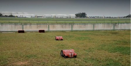
Each robotic grass cutter is programmed to maintain specific turfed zones in a coordinated approach and automatically head back to their huts to recharge when battery level runs low
Signal wires buried in the soil demarcate the permissible movement zone of each robotic grass cutter so that they perform their roles in a coordinated manner without overlap or gaps. Through this mechanism, they are also geo-fenced to avoid intruding into the safety zone of aircraft movement areas. CAG’s engineering team is studying potential risks, such as stability of robots under aircraft jet blast steams, so as to be able to deploy them more extensively to cover the entire airfield, paving the way to a truly transformed ‘man-less’ grass cutting regime in the near future.
Seeing in the dark and below ground
Upkeeping the airfield lighting system at Changi Airport is a mission-critical task as pilots rely on these navigational visual aids to manoeuvre aircraft safely under low visibility conditions and in the night. One key element affecting the reliability of airfield lighting serviceability is the health of hundreds of kilometres of airfield lighting cables that run from the airport power supply substations to each light fitting installed on the runways, taxiways and aircraft parking aprons. These cables run through ducts buried underground throughout the airfield and are only accessible through opening manholes, draw pits and transformer pits located at intervals along their route.
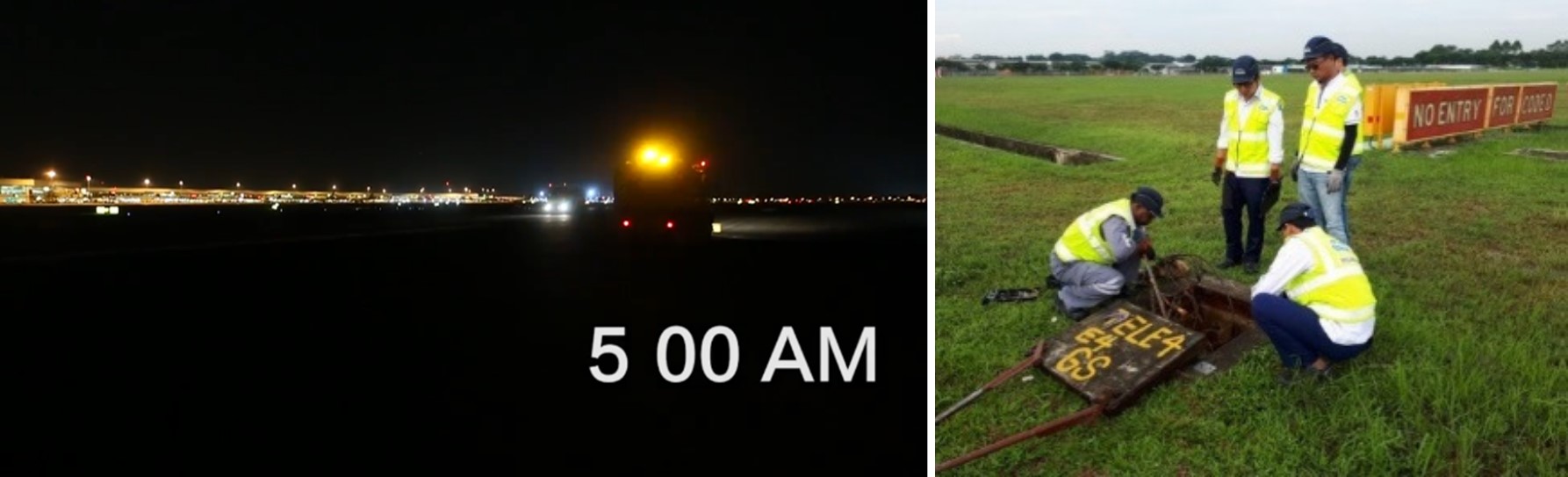
Left: Pitch darkness of Changi Airport’s runway when viewed on site at night
Right: Maintenance staff accessing transformer pit for airfield lighting underground cable condition inspection
As most of the maintenance work can only be carried out at night during lull period, locating and accessing these underground assets efficiently can be a daunting task in the dark or in adverse weather conditions. When there is a cable fault, the ability to trace their routes without being able to see them on site, as well as troubleshooting to pin-point the exact segment of cable failure for immediate repair/replacement has also been very challenging.
With this problem definition in mind, CAG engineers worked with a local technology vendor to develop a mobile app that digitally captures the exact GPS coordinates and routes of underground airfield cables and their associated manhole, draw pit and transformer pit positions so as to enable maintenance staff to digitally see and physically reach them accurately and easily.
Named C.A.T. for Changi Airfield-Lighting Tool, the software app displays the real-time position of maintenance staff in the airfield environment with respect to nearby landmarks such as runway//taxiway boundaries and airfield lighting fitting locations. Overlayed on the mobile app display are the plotted virtual routes of underground airfield lighting cables and the specific manholes, draw pits and transformer pits associated with each airfield lighting circuit. Using the app, maintenance staff can easily ‘visualise’ how the cables of a selected airfield lighting circuit runs underground and how they loop around specific manholes and pits for speedy troubleshooting and repair. Based on directional guidance provided by the app, staff can track their own movements with respect to nearby underground cable routes and surface objects using GPS mapping technology.
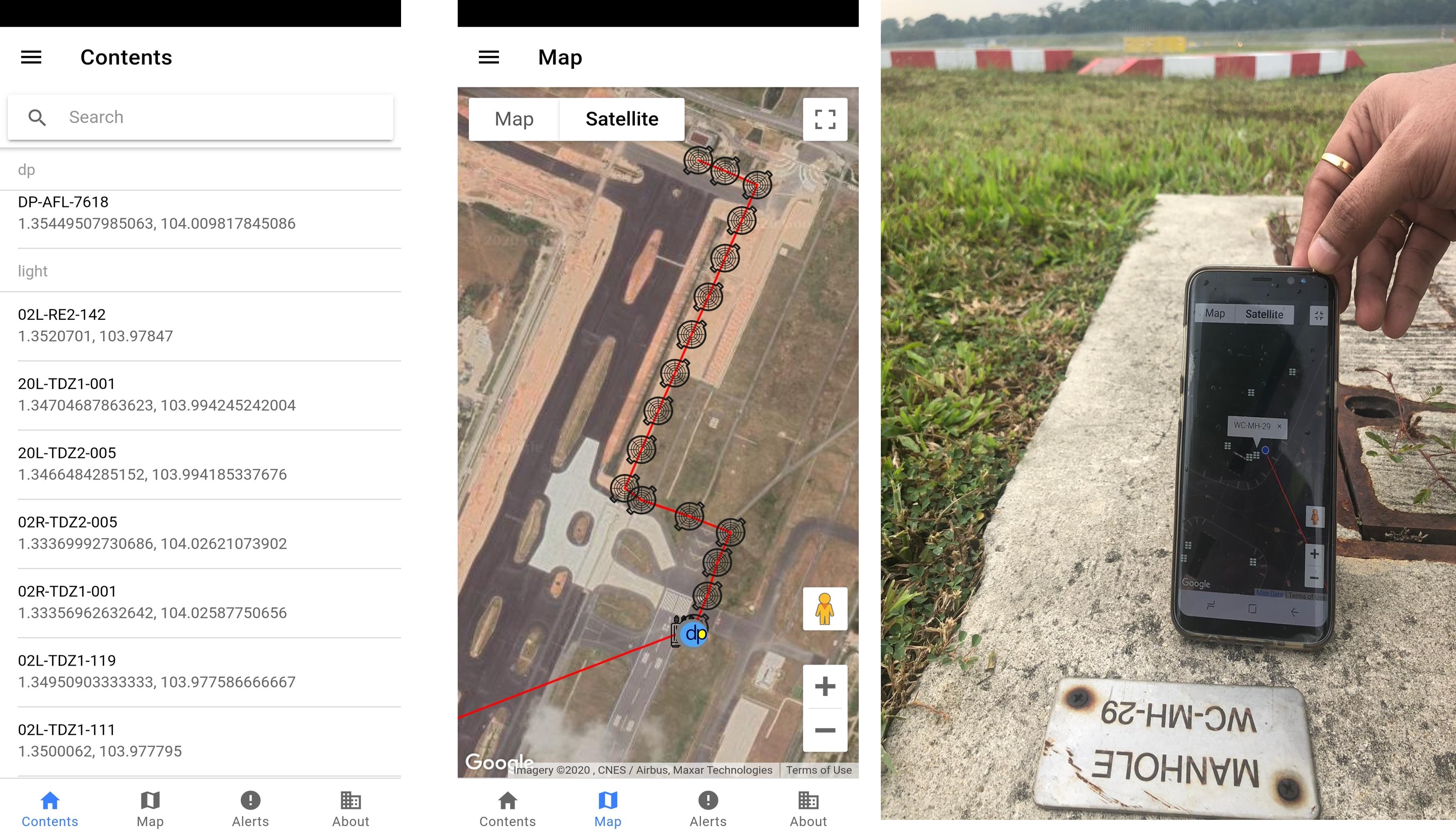
The C.A.T. tool works in the same way as Google Maps, enabling maintenance staff to virtually see the exact underground route, connected surface manholes, draw pits and transformer pits associated with any selected airfield lighting circuit
The CAG engineering team will be progressively populating as-built underground airfield lighting cable route data from paper records into such application tools to scale up its use. To take the innovation effort further, the team is also working with a technology partner to trial an Augmented Reality feature where maintenance staff can “see” through a portable device, such as a tablet with a camera, to scan the site and view underground services in three-dimensional representation, as if having ‘X-ray’ vision.
Other Articles

How Covid-19 brought iShopChangi out of the airport
Learn how iShopChangi’s pandemic pivot gave it a new lease of life, by bringing airport shopping out of the airport
Empowering the innovators of tomorrow
Changi Foundation’s latest partnership with Hatch supports training and job-matching opportunities for youth in digital and design industries

Heart of the matter – Spreading kindness to lift spirits
Through simple acts of kindness, Changi’s airport staff encouraged one another to keep the ONE Changi spirit high